October Service Run
We're back! The stations have been happily recording data for 6 months and so we're back in the desert to make sure all is going well and bring back the data to start our preliminary analysis. Myself (Rob) is leading the service run and I'm accompanied by three fantastic UT grad students, Simone, Kelly, and Brandon. Simone is a first year student in Thorsten Becker's geodynamics group, while Brandon works with Harm van Avendonk on marine geophysics and Kelly works with Nathan Bangs, also on marine geophysics. They've all had field experience before, but this is their first time with passive, broadband seismometers in the desert.
In planning the service run, I was expecting about 6 days total: 2 days of primarily travel and 4 days of primarily work. On our travel day, we did a team service at an easily accessible site and decided we had enough daylight to do a second. So by the end of the first travel day, we already had 2 sites done.
On the first work day, we planned to knock out the hardest ones. Simone and Kelly went on a ~12km hike to hit MOJN, MOJO, and MOJP in a loop. They had no major problems and were back in Barstow by 6pm. Rob and Brandon went for the other three stations at the east end of the line, MOJS, MOJR, and MOJQ. When we got to MOJS, after about 1.5 hours on the highway and 1 hour on a dirt road, we found the station in good shape, but forgot to bring the adapter needed to connect my computer with the microSD card. Arggg! Two and a half hours of driving and we couldn't download the data. So we drove back to Barstow, picked up the connector, and went to MOJA and MOJB instead. MOJA was our group install back in April and took a pretty good hike to get to. MOJB wasn't far from the road, so we collected that one's data pretty easily and made it back to Barstow by about 5:30.
So far, the main statement of this trip has been, "wow, that's beautiful" as we look out at the painted mountains which look straight off Bob Ross's canvas. This is truly a wonderful place to work... when the weather is not 120˚F.
At each station we have three primary tasks. First, make sure everything is working ok. We have a handful of spare equipment we hike in with and tools that should allow us to fix any obvious problems. Second, download the data. The data cards are about 1/3 full, so we've got about another year's worth of recording before the cards fill up and start wrapping. Third, we are adding a blue fire hose material around the cables connecting the sensor and the digitizer. Critters love chewing these cables and we found one station, MOJB, had a piece of the cable gnawed off, but not through. Threading the cables through the fire hose should protect them from any more curious desert critters.

A flask nestled in a cairn just off the road. I'm guessing this is an old geocaching site.

The end of the wash that leads to MOJA - a little too rough for our truck to handle.

Martian landscape out in Mojave.

I'm not quite sure what kind of rock this is. We had a long debate whether these round bits could be desert rose (barite) or due to ash fall.

A happy station about to get its blue hose to cover the sensor cable.

Just another gorgeous landscape

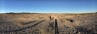
Kelly and shadows.

Happy little station.

Another little landscape with Brandon

Cavitation built along the sides of the wash

Happy little station

Looks like the burrow of some desert critter

Gotta love the view.


Comments
Post a Comment